The St. Arnaud Range Track, when described to us by the friendly staff at the Nelson Lakes National Park Visitor Centre, sounded too like Mount Stokes for Dina. With that disappointment fresh in her mind, she decided to leave me to go gallivanting up another mountain on my own.
They described it to us as a challenging hike that goes out and back along the same path which is ‘Good if you get the right weather.’ The forecast for the following morning was good, so I thought it was worth the risk if I got up early. So after a 6am alarm, I found myself on another Saturday morning, wearing my Park Run t-shirt, facing a different kind of 5km route.
The according to the map, the first 5km would be spent climbing around 1000m through trees with very little to look out upon. Possibly to keep myself entertained on my solo hike, or possibly because I'd read on a board at the visitor centre that Sandflies (the New Zealand native biting insect which are quite prevalent in the area) struggle to latch on to moving targets, I decided to try to get through the dull first 5km as quickly as possible.
The track started similarly to most New Zealand forest hikes that I've experienced. Walking through trees, occasionally coming across an orange triangle nailed into one of them, confirming you're still on track and pointing you in the direction you're supposed to be going. You follow them, somewhat blindly, like a child with a dot-to-dot drawing, similarly hoping for a grand reveal at the end.
To call it dull might be a bit harsh. Although there wasn't really a view out to see what progress you'd made on the climb, I was predominantly heading east, and with the morning sun shining through the trees, it was actually quite beautiful. Certainly if I'd had these conditions in the New Forest in the past I would've been enchanted by it, but having seen the Milky Way over Lake Rotoiti with my bare eyes the night before, a bit of lime green moss on some trees didn't have the same effect as it used to. I need to remember not to get complacent.
As I pressed on I began to notice I was seeing less and less of the sun coming through the trees. Was it clouding over? Was I destined to repeat our Mount Stokes experience? Suddenly I realised - I was moving into the shadow of the mountain faster than the sun could get over it. Pleased with this realisation I glanced at my GPS watch and saw that I'd done 2.3km in 30 minutes. I was pretty pleased with myself. I mean, I know I’m pretty fit, but I didn't know I was that fit. At this rate maybe I'd be able to get to the view in just over an hour…
No.
Looking at my watch was possibly the worst thing I could've done. I should've learned this as a child on Christmas eve. Time passes quicker when you aren't thinking about it. What I'd actually done was opened Pandora's box. All I wanted to do was look at my watch and see how much more progress I'd made. It must've been another 500, maybe even 750 metres, right? More like 150m. At the hour I'd managed 3.75km.
After what seemed like an age of climbing and climbing, switchback after switchback, with more lactic acid flooding my legs and my breathing getting heavier as the air got a little thinner, I made it through the trees. Immediately above me was parachute rocks, a rock formation sticking out and forming a natural pedestal. I climbed up on to it and checked my watch. One hour and twenty-six minutes - closer to a half marathon record than anything.
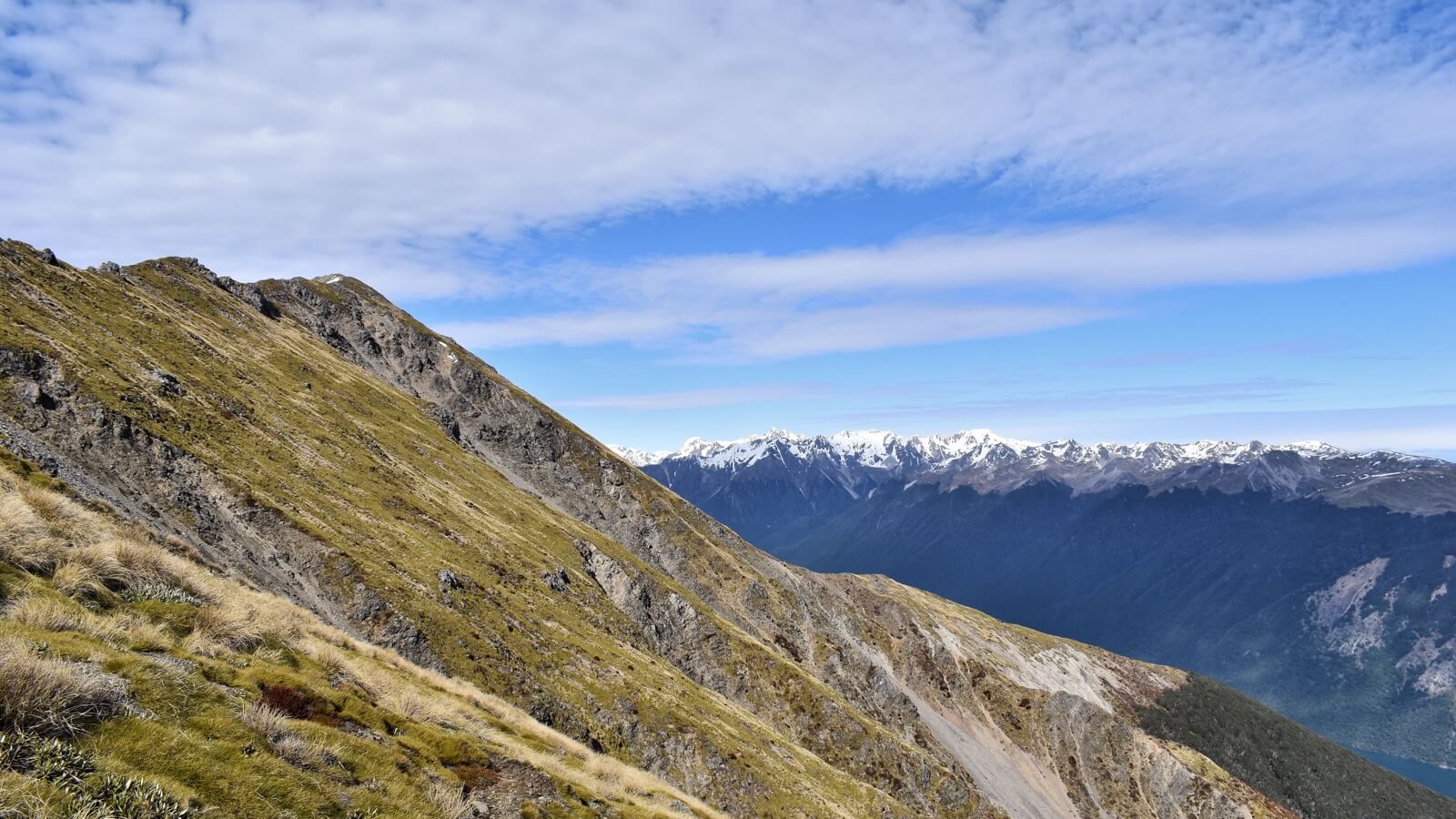
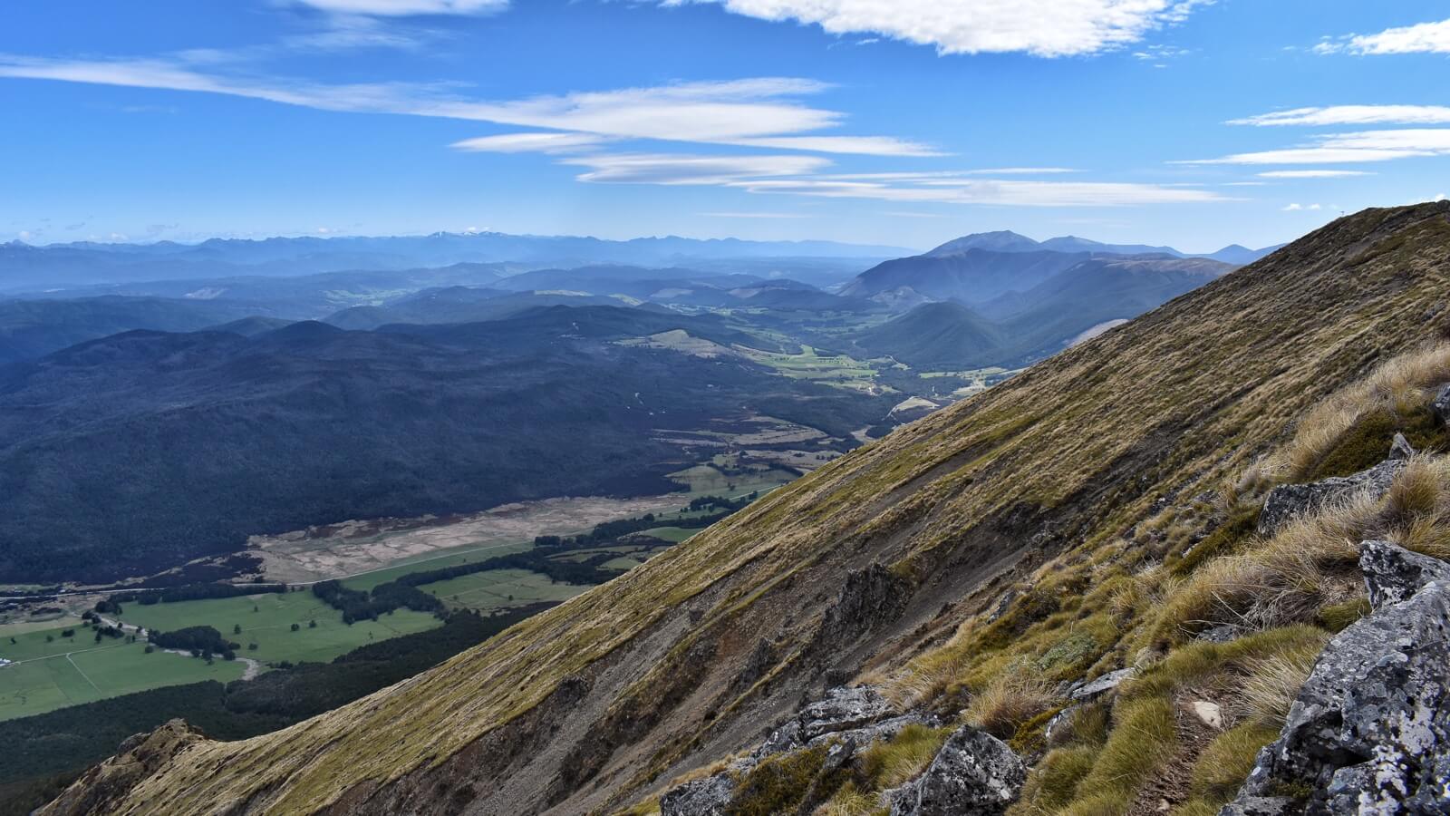
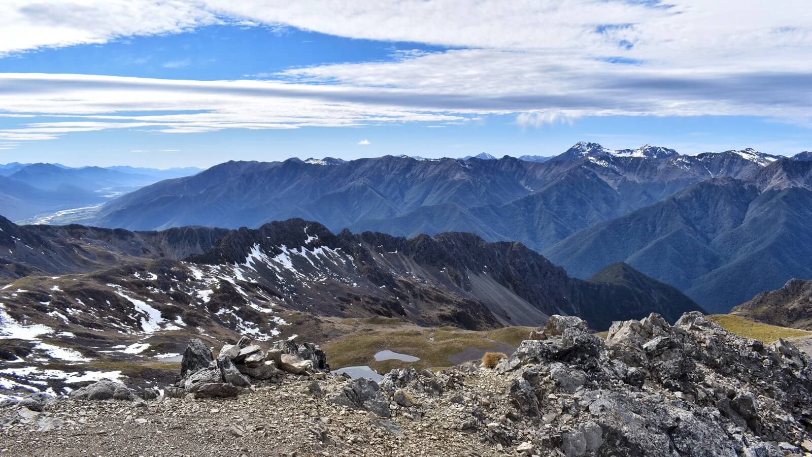
The view from parachute rocks was fantastic and I was the only one there so I paused there to get my breath back and grab a snack. However, the track wasn't called the St Arnaud Range Track for no reason. As you look out over the view of the lake and on to the mountains in the west, behind you is a near 45 degree angle of scree that leads up to the St Arnaud Range - a ridge that runs north-south, sending water down its western slopes to feed the lake.
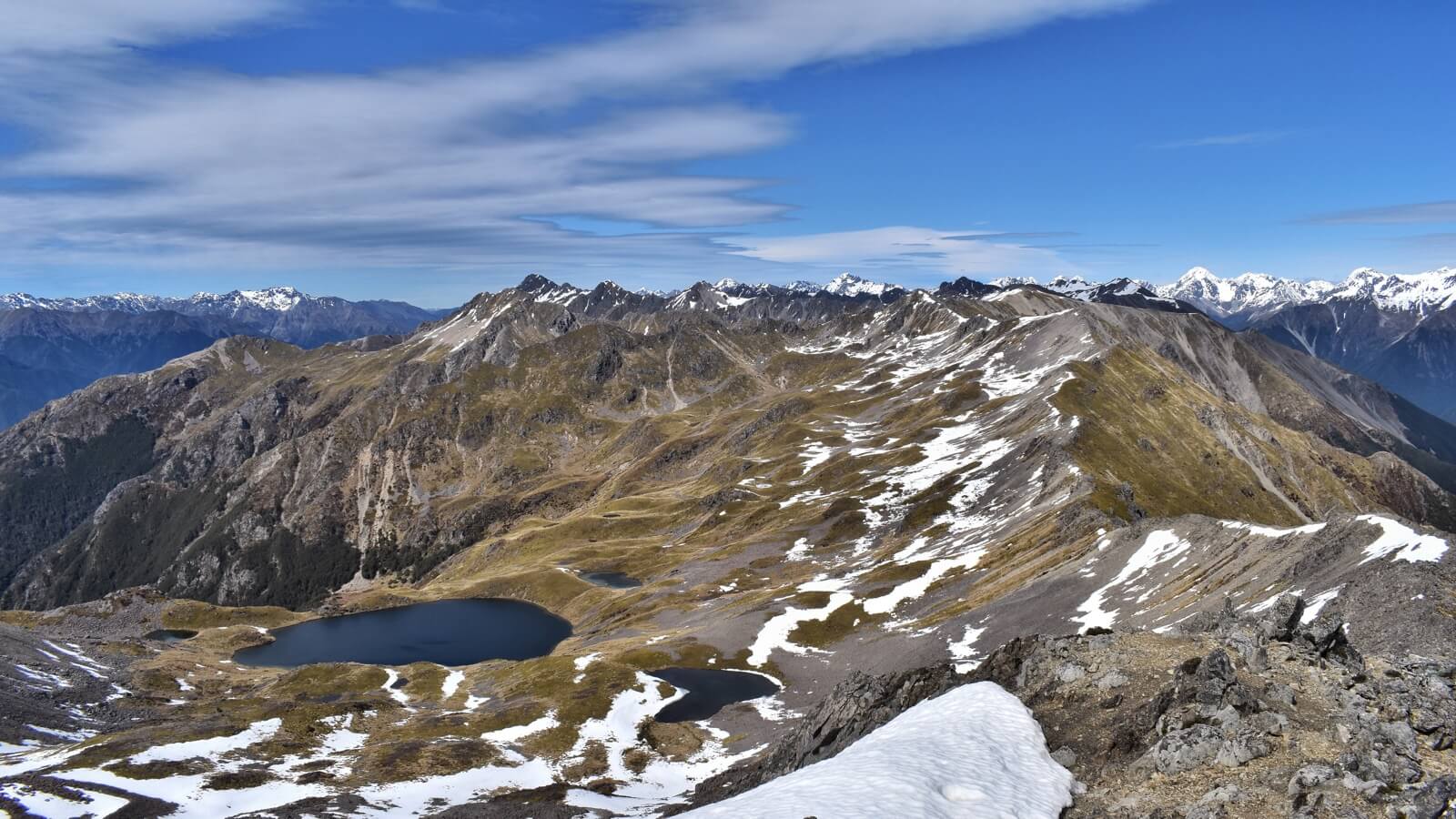
My eyes followed the ridge southward to a peak which looked pretty achievable so I thought I'd continue. The climb was definitely physically tougher than that through the forest, but psychologically it was much easier - I could see my target the whole way and I knew it wasn't far. I can't tell you how much time it took me to climb up to the ridge for the simple reason that when I reached it I didn't care about time any more. The view from parachute rocks had been great, but the view from the ridge was better - snow capped mountains in every direction.
With the hard climbing done, I practically skipped along the ridge. I had a hairy moment or two with what looked to me like regular dirt but turned out to be frozen mud, which when stepped on became unexpectedly slippery, but mostly it was just great fun. There was enough snow to make it beautiful but not enough to be dangerous. My mind went back to climbing Helvellyn this summer, a mountain in the Lake District in the north of the UK which can be climbed via a ridge called Striding Edge. The drop off on Striding Edge was probably a bit steeper but the view here was better, not least because our Helvellyn climb was through cloud.
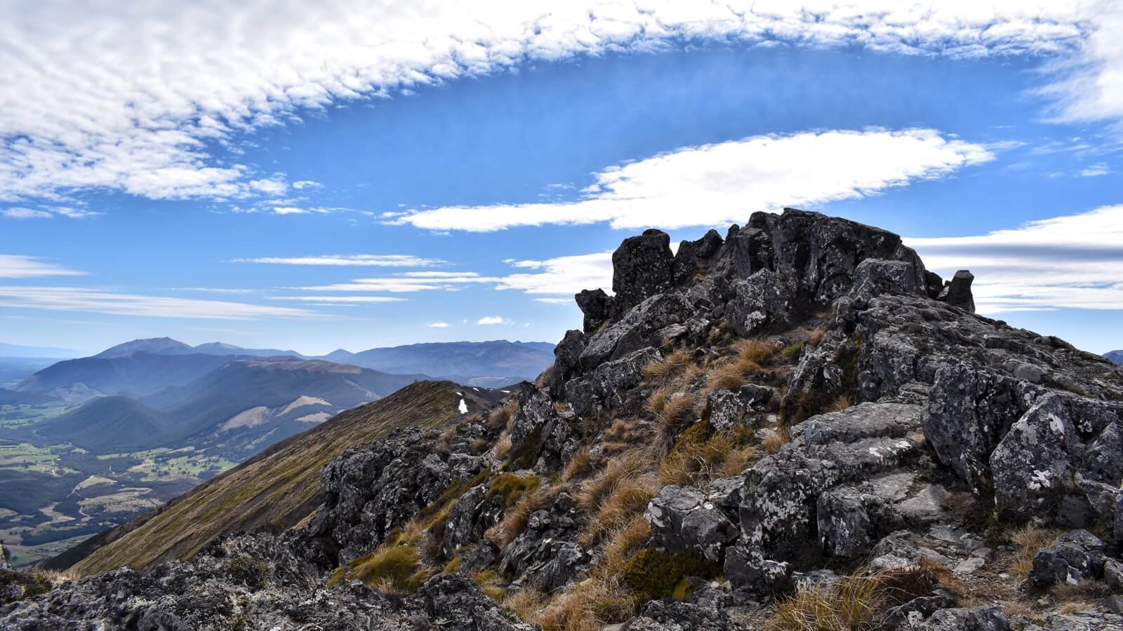
I was happily climbing when I unexpectedly reached a cairn - a pile of stones that marked the top. As a twenty-first century man I chose the only way I know how to celebrate the occasion - it was time to document my achievements with my drone. The wind at the top got to me a bit more than the drone, so after about 15 minutes on the top of the world I packed up and started to descend.
In the time I'd been on the top, I'd seen a few brightly coloured dots arriving on parachute rocks and a couple of them making the climb up to the ridge, but so far none had attempted to climb along it. As I made it to the place where it was time to descend off the ridge I ran into a middle-aged couple. ‘Excuse me. Were you flying a drone back there?’ Asked the woman, in an accent so German that I was really tempted to type it phonetically. ‘I ask because I’m interested in buying one myself.’ Still riding on the euphoria of the view I proceeded to become an advocate for my Spark. If DJI would like to get in touch I'd be happy to provide bank details for my sales commission.
Back at parachute rocks I briefly spoke to a couple of Australians who were cracking open what looked like celebratory beers. I encouraged them to go for the top and then proceeded to head back to the forest. Going down through the trees was hard on the knees, but the top had made it more than worth it. There had been almost nobody on the whole route. Presumably everyone else had been on the slightly easier and more popular Mount Robert Circular route, which we intended to do the following day.
As I arrived back at the van I tried to hide my elation from Dina. In the time I'd been away she'd had a good run, training for a 10k we're doing in Queenstown in mid-November. I hope you can keep a secret, dear reader, but that might've been my favourite hike in New Zealand so far. You won't tell her, right?